


Description
This rugged GPS handheld has a modern design, preloaded maps and built-in inReach® Plus technology1 to stay in touch beyond cellular coverage. It’s time to hit the trails.
Garmin today unveiled the adventure-ready GPSMAP® H1i Plus, an exciting new flagship GPS handheld navigator that boasts higher-bandwidth inReach® Plus technology to give users more ways to stay in touch beyond cellular coverage1. With an active inReach plan, hikers, backpackers, mountaineers and passionate adventurers who go off-grid can snap and share photos directly from the device as well as exchange voice memos and texts. Users are also able to trigger an interactive SOS message in the event of an emergency. Reimagined with a bright, sunlight-readable 3.5-inch touchscreen and physical buttons for increased flexibility, the GPSMAP H1i Plus boasts up to 145 hours of battery life and extensive preloaded maps with the option to purchase an Outdoor Maps+ plan for access to premium mapping content.
“When your journey takes you off the grid, the new GPSMAP H1i Plus lets you connect with loved ones through a photo, a text message or a voice memo where cell phones do not work. Now, you can share your adventures in real-time, sending photos when you’re at the mountain summit or communicate with friends and family from the trail. The inReach Plus capabilities also give users peace of mind when exploring, allowing them to trigger an SOS message to Garmin Response and provide loved ones back home the ability to track their location during the expedition.”
Superior inReach Plus technology
With an active inReach plan, the GPSMAP H1i Plus not only helps users stay in touch with family, friends and others in their group, it can also provide communication with emergency services when needed. In the event of an emergency, it can send an interactive SOS text message to Garmin ResponseSM, a 24/7-staffed international emergency assistance coordination center. They provide updates to users and emergency contacts on the response effort, including confirmation when help is on the way, and remain available as the incident is being resolved. Photo and voice messages can also be shared, giving response coordinators the ability to see and hear details of the emergency first-hand.
With no satellite dead zones, users can enjoy higher-bandwidth communication when traversing through wilderness. What’s more, when venturing off-the-grid, loved ones back home can follow along using LiveTrack™ location sharing see a user’s trip progress, including distance, time and elevation.
Touchscreen Display
The bright, sunlight-readable 3.5″ colour touchscreen has chemically strengthened glass to resist scratches. It is glove-friendly, easy to see and easy to use. Tap, zoom and swipe on the maps to follow your route.
PHYSICAL BUTTONS
The rugged hybrid design also features intuitive push buttons for more versatility when in weather and while wearing gloves. The quick-action button lets users customise functions to their specific needs.
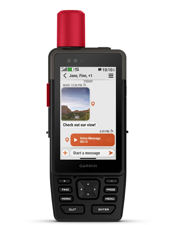
PHOTOS AND VOICE/TEXT MESSAGING
With an active inReach subscription1, send group text messages up to 1,600 characters. You can also exchange photos and voice messages when outside of cellular coverage.
SOS ALERTS
Trigger an interactive SOS message anytime to the 24/7-staffed Garmin Response international coordination centre for help in an emergency. This requires an active inReach subscription1.
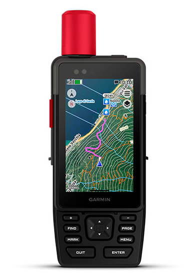
Advanced Navigation
Navigate with preloaded TopoActive maps for Australia and New-Zealand — and easy-to-access global maps. See terrain contours, elevations, geographical points and more.
SATELLITE IMAGERY
Download high-resolution photorealistic maps directly to your device via Wi-Fi® technology. Find trails, pick stand locations and parking, create waypoints and more.
OUTDOOR MAPS+
Purchase an Outdoor Maps+ plan for access to a variety of premium mapping content across the globe. Plans are updated regularly and sent to your device over Wi-Fi.
LOCATION ACCURACY
Get multi-band GPS and multi-GNSS support for superior positional accuracy.
BUILT-IN CAMERAS
The integrated front and back cameras allow you to snap selfies and photos of your trip. With an active inReach subscription1, share your photos in real time even without a cellular network.
VOICE CONTROL
Utilise voice commands to conveniently handle many tasks, including check-ins, start tracking, take a photo and more. Available in Danish, Dutch, English, French, German, Italian, Spanish and Swedish.
LIVETRACK™ SHARING
When you venture off-grid, friends can follow along via satellite technology1 to view your progress, ping your device to see your GPS location and exchange messages. For trips within cellular range, loved ones can follow your location in real time and see data such as distance, time and elevation.
GARMIN WEATHER
Get real-time forecast information so you’re aware of the changing conditions. This feature requires an active Wi-Fi connection or an active cellular connection and use of the Garmin Messenger™ app on your paired smartphone. When you travel beyond cell range, access weather updates via satellite1 for your current location, route destination and more.
PLAN YOUR TRIPS
Enjoy seamless trip planning with the ability to easily locate geographic points, share your route and more. This requires an active Wi-Fi connection or cellular connection with use of the Garmin Explore™ app on your compatible smartphone.
HELPFUL TOOLS
Use the built-in bright LED flashlight torch as a beacon or to light your way when the path goes dark. A loud built-in siren can help draw attention if you are in need.
BATTERY LIFE
Long-lasting battery life allows for up to 145 hours in GPS mode.
RUGGED DESIGN
Built to meet MIL-STD 810 for thermal, shock, water (IPX67) and vibration to withstand weather and extreme temperatures.
ON THE GO
This device has an integrated Spine Mount 2 and includes a removable loop with carabiner clip for more versatility on your adventure. It’s also compatible with additional Spine Mount 2 accessories, sold separately.
ABC SENSORS
Get a built-in altimeter for elevation data, a barometer to monitor weather and a 3-axis electronic compass to provide direction.